

Bryce Canyon National Park day trip from Zion National Park
A day trip to Bryce Canyon National Park from Zion National Park: the drive to Rainbow Point, the highest viewpoint at the end of the park road, then the rim views on the way back, from the Natural Bridge arch and Bryce and Inspiration Points over the Bryce Amphitheater, and an afternoon hike down among the hoodoos on the Navajo Loop and Queens Garden Trail. Every stop has a typical visit length.
How long do you have?
Map: 1 days
Bryce Canyon National Park in 1 day
Day 1

Rainbow Point
The highest point of the park at the end of the scenic road, with views far over the Grand Staircase and a short bristlecone pine trail.
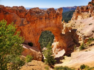
Natural Bridge
Roadside viewpoint over a large arch of red rock spanning a gully, named a bridge though it was carved by rain and frost.

Bryce Point
Viewpoint at the south end of the amphitheater with a view along the whole bowl of hoodoos, and the start of the Peekaboo Loop.

Inspiration Point
Higher viewpoint on the rim looking down on the rows of hoodoos known as the Silent City, one of the park's finest views.

Navajo Loop and Queens Garden Trail
Popular loop of about three miles from the rim down among the hoodoos, through the narrow Wall Street and past Thor's Hammer and Queen Victoria.
Getting there
Bryce Canyon is about 1.5-2 hours by car from Zion's east entrance, through the Zion-Mount Carmel tunnel, then north on US-89 and east on Scenic Byway 12 through the red rock arches of Red Canyon. Large RVs need a permit and escort for the Zion tunnel. Inside the park a single road runs about 18 miles along the rim to Rainbow Point.
Staying in Zion National Park? This day fits into those city plans, and in the Trip Builder it is one click under each of them.
When to go to Bryce Canyon National Park
May, June, September and October are the best months, with mild days and cool nights. July and August are busy, with afternoon thunderstorms, though Bryce is rarely as hot as Zion. Winter brings snow on the hoodoos, cold nights and road closures beyond some viewpoints during storms; the Bryce Canyon Winter Festival is held in February.
Plan the rest of your trip
- Where to stay: hotels in Bryce Canyon National Park on Booking.com or Trip.com
- Skip-the-line tickets: museums and sights in Bryce Canyon National Park on Tiqets
- Tours and day trips: things to do in Bryce Canyon National Park on GetYourGuide
- Data on arrival: an eSIM for United States from Airalo
Some of these are affiliate links: we may earn a small commission at no extra cost to you.
Tips for Bryce Canyon National Park
- The rim is at 8,000-9,000 feet: mornings are cold even in summer, the air is thin, and trails back up to the rim feel steep. Bring layers and plenty of water.
- A free shuttle runs from April to mid-October to the main viewpoints of the amphitheater; it is optional but saves hunting for parking.
- All the viewpoints are on the east side of the road: drive to Rainbow Point first and stop at the others on the way back.
- The Navajo Loop and Queens Garden hike starts at Sunset Point and ends at Sunrise Point; summer afternoons bring thunderstorms, so watch the sky and keep off the rim in lightning.
- Trail sections, such as Wall Street on the Navajo Loop, can close in winter or after rockfall; check at the visitor centre.
Make it your own
Open the guide in Andiamo Places to see every stop on a map with walking directions, move places between days, check opening hours for your dates, and add your own finds. After the trip, your photos become a journal and, if you like, a printed photo book.



Guides are made with the help of AI and public sources such as Wikipedia, and may contain errors. Opening hours and prices change, so check before you go. Spotted a wrong photo, a pin in the wrong place, a missing stop or a better one? Write to andiamotravelapp@gmail.com: the e-mail opens with this guide filled in.
Photo credits
- Bryce Point: © Pierre André, CC BY-SA 4.0
- Inspiration Point: Autumn1198, CC BY-SA 4.0
- Navajo Loop and Queens Garden Trail: Christian David, CC BY-SA 4.0
- Rainbow Point: Ken Lund from Reno, Nevada, USA, CC BY-SA 2.0
Opening hours change; check before you go. Map data © OpenStreetMap contributors.
