

Anza-Borrego Desert day trip from San Diego or Palm Springs and Joshua Tree
A day trip to Anza-Borrego Desert State Park from San Diego: the hike up Borrego Palm Canyon to a palm oasis first thing, then the Visitor Center, Ricardo Breceda's giant metal sculptures around Borrego Springs, a walk through The Slot, a narrow slot canyon, and the view over the Borrego Badlands from Fonts Point at sunset. Every stop has a typical visit length. For the city itself, see the San Diego page.
How long do you have?
Map: 1 days
Anza-Borrego Desert in 1 day
Day 1

Borrego Palm Canyon trail
Trail up a rocky canyon to a grove of native fan palms by a stream, with bighorn sheep often on the slopes.
Anza-Borrego Desert State Park Visitor Center
The park's visitor centre, built partly underground, with exhibits on desert life, a desert garden, and maps and road advice.

Galleta Meadows metal sculptures
More than a hundred giant metal sculptures by Ricardo Breceda, from dinosaurs to a sea serpent, spread across open desert around Borrego Springs.
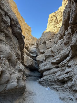
The Slot
Short walk through a narrow, twisting slot canyon off CA-78, squeezing between sandstone walls; avoid it in flash-flood weather.
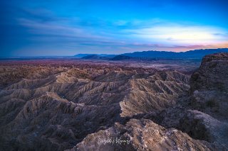
Fonts Point
Viewpoint over the deeply eroded Borrego Badlands, best late in the day when the low sun picks out every ridge.
Getting there
Borrego Springs is about two hours by car from San Diego, usually through Julian and down the Banner Grade on CA-78, or over the Montezuma Grade on S-22 from Ranchita. There is no public transport. Fonts Point and The Slot are on dirt roads: high clearance or 4WD is often needed for the last part of Fonts Point.
Staying in San Diego or Palm Springs and Joshua Tree? This day fits into those city plans, and in the Trip Builder it is one click under each of them.
When to go to Anza-Borrego Desert
Visit from about October to April. Wildflowers bloom about February to March, depending on winter rain, and good years bring big crowds. From about May to September the heat is extreme, often over 100 F (38 C), and hiking is unsafe except at dawn.
Plan the rest of your trip
- Where to stay: hotels in Anza-Borrego Desert on Booking.com or Trip.com
- Skip-the-line tickets: museums and sights in Anza-Borrego Desert on Tiqets
- Tours and day trips: things to do in Anza-Borrego Desert on GetYourGuide
- Data on arrival: an eSIM for United States from Airalo
Some of these are affiliate links: we may earn a small commission at no extra cost to you.
Tips for Anza-Borrego Desert
- Carry far more water than you think, plus food: services are only in Borrego Springs, and phone signal is patchy in the park.
- Start the Borrego Palm Canyon hike early, before the heat, and look for bighorn sheep on the slopes; a day-use fee is charged there.
- Ask at the Visitor Center about the dirt roads to Fonts Point and The Slot; sandy washes can stop ordinary cars, and flash floods follow storms.
- In wildflower season, ask at the Visitor Center where the bloom is best, and come on a weekday if you can.
- Borrego Springs is a Dark Sky Community: stay for the stars if you can drive back after dark, or sleep in town.
Make it your own
Open the guide in Andiamo Places to see every stop on a map with walking directions, move places between days, check opening hours for your dates, and add your own finds. After the trip, your photos become a journal and, if you like, a printed photo book.



Guides are made with the help of AI and public sources such as Wikipedia, and may contain errors. Opening hours and prices change, so check before you go. Spotted a wrong photo, a pin in the wrong place, a missing stop or a better one? Write to andiamotravelapp@gmail.com: the e-mail opens with this guide filled in.
Photo credits
- Anza-Borrego Desert State Park Visitor Center: No machine-readable author provided. Miskatonic assumed (based on copyright claims)., CC BY 2.5
- Borrego Palm Canyon trail: No machine-readable author provided. Miskatonic assumed (based on copyright claims)., CC BY 2.5
- Galleta Meadows metal sculptures: GB11111, CC BY-SA 4.0
Opening hours change; check before you go. Map data © OpenStreetMap contributors.
