

Puerto Ángel, Zipolite and Mazunte day trip from Puerto Escondido or Huatulco
A day trip to Puerto Ángel, Zipolite and Mazunte from Puerto Escondido or Huatulco: snorkelling at Playa Estacahuite, the fishing bay of Puerto Ángel and Playa Panteón, the long surf beach of Zipolite, the calmer bay of San Agustinillo, the village beach of Mazunte and sunset from the Punta Cometa headland. Every stop has a typical visit length.
How long do you have?
Map: 1 days
Puerto Ángel, Zipolite and Mazunte in 1 day
Day 1
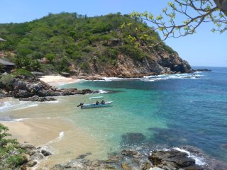
Playa Estacahuite (snorkelling)
Small sheltered coves just east of Puerto Ángel with clear water and coral, good for snorkelling, with simple palapa restaurants renting masks.

Puerto Ángel bay (Playa Panteón)
The fishing village's horseshoe bay, where boats land the catch; Playa Panteón has calm water for swimming and seafood restaurants on the sand.

Zipolite beach
Long open surf beach with a laid-back village of beach bars, cabins and yoga, known as a clothing-optional beach; swim with care.

San Agustinillo beach
Small fishing village with a gentle curved bay between Zipolite and Mazunte, good for swimming, bodyboarding and long seafood lunches.

Playa Mazunte
The village beach of Mazunte on a sandy bay with gentle waves, palapa restaurants and a relaxed yoga-and-hammocks feel; the Mexican Turtle Centre is close by.

Punta Cometa (sunset)
Rocky headland at the western end of Mazunte, reached by a short path, where people gather on the rocks to watch the sun set over the Pacific.
Watch: Puerto Ángel, Zipolite and Mazunte
A one-minute look at the plan: every stop, day by day, with the map.
Getting there
From Huatulco, Puerto Ángel is about 50 minutes by car or taxi along the coast road, or by bus or colectivo to Pochutla and a colectivo on. From Puerto Escondido it is about an hour and a half by car, or by bus to Pochutla and a colectivo down to the coast; colectivos then link the beaches.
Staying in Puerto Escondido or Huatulco? This day fits into those city plans, and in the Trip Builder it is one click under each of them.
When to go to Puerto Ángel, Zipolite and Mazunte
November to April is the dry season, with sunny days and calmer seas, and the busiest time, especially around Christmas and Easter. May to October is the rainy season, hotter and more humid, with afternoon storms and a risk of hurricanes mainly from August to October. Olive ridley turtles nest on this coast mainly from summer into autumn.
Plan the rest of your trip
- Where to stay: hotels in Puerto Ángel, Zipolite and Mazunte on Booking.com or Trip.com
- Skip-the-line tickets: museums and sights in Puerto Ángel, Zipolite and Mazunte on Tiqets
- Tours and day trips: things to do in Puerto Ángel, Zipolite and Mazunte on GetYourGuide
- Data on arrival: an eSIM for Mexico from Airalo
Some of these are affiliate links: we may earn a small commission at no extra cost to you.
Tips for Puerto Ángel, Zipolite and Mazunte
- Zipolite has strong waves and rip currents; swim only where it is calm and locals say it is safe, and never alone.
- Zipolite is one of Mexico's best-known clothing-optional beaches; respect people's privacy and ask before taking photos.
- Bring cash: small restaurants, snorkel rentals and colectivos along this coast often don't take cards, and cash machines are few.
- Shared colectivo taxis run along the coast road between Puerto Ángel, Zipolite, San Agustinillo and Mazunte all day; flag one down by the road.
- Stay for sunset at Punta Cometa, a short walk up from Mazunte beach, and bring a torch for the path back down in the dark.
Make it your own
Open the guide in Andiamo Places to see every stop on a map with walking directions, move places between days, check opening hours for your dates, and add your own finds. After the trip, your photos become a journal and, if you like, a printed photo book.



Guides are made with the help of AI and public sources such as Wikipedia, and may contain errors. Opening hours and prices change, so check before you go. Spotted a wrong photo, a pin in the wrong place, a missing stop or a better one? Write to andiamotravelapp@gmail.com: the e-mail opens with this guide filled in.
Photo credits
- Puerto Ángel bay (Playa Panteón): Thelmadatter, CC BY-SA 3.0
- Punta Cometa (sunset): AlejandroLinaresGarcia, CC BY-SA 4.0
- San Agustinillo beach: Jaimalalatete, CC BY-SA 4.0
- Zipolite beach: AlejandroLinaresGarcia, CC BY-SA 4.0
Opening hours change; check before you go. Map data © OpenStreetMap contributors.
