

Belize City in a day
A one-day plan for Belize City: Yarborough Cemetery, St. John's Cathedral and Government House, then Battlefield Park, the Swing Bridge, the Maritime Museum and Holy Redeemer Cathedral, the Image Factory gallery, the Museum of Belize and the Baron Bliss Light. Every stop has a typical visit length.
How long do you have?
Map: 1 days
Belize City in 1 day
Day 1
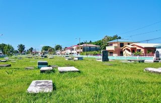
Yarborough Cemetery
The city's first public cemetery, opened in the 1780s, with old colonial-era graves near St. John's Cathedral.

St. John's Cathedral (Belize City)
The oldest Anglican cathedral in Central America, built of brick in the early 1800s with slave labour.

Government House, Belize
Colonial wooden house by the sea, once the governor's home and now the House of Culture, with exhibits and gardens.

Battlefield Park
The main square of downtown Belize City, long the place of political rallies, surrounded by colonial buildings.

Swing Bridge (Belize)
Hand-turned swing bridge over Haulover Creek, one of the few still opened manually, linking the two halves of downtown.
Maritime Museum (Belize)
Small museum by the Swing Bridge on Belize's boats, fishing and seafaring history.

Holy Redeemer Cathedral
The Roman Catholic cathedral of Belize City, on North Front Street near the Swing Bridge.

Image Factory Art Foundation
Non-profit gallery in the city centre showing changing exhibitions of contemporary work by Belizean artists.

Museum of Belize
National museum in the former colonial jail from the 1850s, with Maya artefacts and displays on the history of Belize.

Baron Bliss Light
Small lighthouse at the harbour mouth, beside the tomb of Baron Bliss, who left his fortune to the country.
Watch: Belize City
A one-minute look at the plan: every stop, day by day, with the map.
When to go to Belize City
The dry season from December to April is the most pleasant and the busiest time to visit. June to November is the rainy season and also the Caribbean hurricane season, with the highest risk from August to October. September brings the national celebrations of the Battle of St. George's Caye and Independence Day.
Plan the rest of your trip
- Where to stay: hotels in Belize City on Booking.com or Trip.com
- Skip-the-line tickets: museums and sights in Belize City on Tiqets
- Tours and day trips: things to do in Belize City on GetYourGuide or on Viator
- Data on arrival: an eSIM for Belize from Airalo
Some of these are affiliate links: we may earn a small commission at no extra cost to you.
Tips for Belize City
- Most sights sit on either side of Haulover Creek and are linked by the Swing Bridge, so the day can be walked.
- Walk in daylight and stay on busy streets; use licensed taxis after dark.
- The rainy season, roughly June to November, brings heavy showers; plan indoor stops for the afternoon.
- Cruise ships bring crowds to the waterfront on some days; visit the museums early on those mornings.
- Belize City is also the base for boat trips to the cayes and the Belize Barrier Reef; book them ahead in the busy season.
Make it your own
Open the guide in Andiamo Places to see every stop on a map with walking directions, move places between days, check opening hours for your dates, and add your own finds. After the trip, your photos become a journal and, if you like, a printed photo book.



Guides are made with the help of AI and public sources such as Wikipedia, and may contain errors. Opening hours and prices change, so check before you go. Spotted a wrong photo, a pin in the wrong place, a missing stop or a better one? Write to andiamotravelapp@gmail.com: the e-mail opens with this guide filled in.
Photo credits
- Baron Bliss Light: Danakosko, CC BY 2.0
- Battlefield Park: Silver Dovelet, CC BY-SA 3.0
- Government House, Belize: JERRYE AND ROY KLOTZ MD, CC BY-SA 3.0
- Holy Redeemer Cathedral: Ruben Wong, CC BY-SA 3.0
- Museum of Belize: Psubhashish, CC BY-SA 4.0
- St. John's Cathedral (Belize City): Adam Buhler from Lawrence, KS, United States, CC BY 2.0
- Swing Bridge (Belize): Haakon S. Krohn, CC BY-SA 3.0
Opening hours change; check before you go. Map data © OpenStreetMap contributors.
